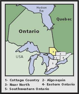
Near North Ontario Backroad Mapbook |
| The "Near North" of Ontario lies in the heart of the Canadian
Shield. Rocky, hilly terrain, including the magnificent mountains of Killarney,
makes up this outdoor paradise. Lake Nipissing dominates the area, with the
historic French River flowing west and the Mattawa River flowing east from the
big lake. From fishing to paddling, from hiking to backroading, the
opportunities are limitless. The reference section found in this book includes information on multi-use trails, lake and stream fishing, provincial parks and conservation areas, paddling, wilderness camping and winter recreation. |
| The maps in this book highlight the logging/bush road
network, trail systems and recreation opportunities for Ontario's Near North. A
unique feature of the maps is that all recreation activities are labelled,
allowing for quick and easy referencing when researching a specific area. No
other source provides as much detail and accuracy on the road and trail
networks of Ontario's Near North. Written by Jason Marleau, Russell and Wesley Mussio. Published by Mussio Ventures Ltd, 2004. |
|
|
| Catalogue No. | 1-894556-34-8 |
| Price | $20.95 |
| Format | Softcover |
| Pages | 50 |
| Language | English only |
| Price and availability subject to change.
Shipping and applicable taxes extra. Questions about this product? Please e-mail us. Last modified: March 6, 2006 |
| Travel in Ontario main page · Maps of Ontario main page |
| What's New · Home · Search · Books on Canada · Canadian Maps and Charts · Ordering · E-mail Us |
©Federal Publications Inc., 1998 - 2006 165 University Avenue, Toronto, Ontario, Canada M5H 3B8 Phone: (416) 860-1611 or toll-free 1-888-433-3782 · E-mail: info@fedpubs.com |