| FEDERAL PUBLICATIONS INC. |
| |
|
Quo Vadis Navigator: Quebec Toporama CD-ROM |
| Catalogue No. | QVNTOQC | |
| Price | $49.95 | |
| Format | CD-ROM | |
| Pages | N/A | |
| Language | Bilingual | |
| Published by Bungert PC-Service, 2003. Description: |
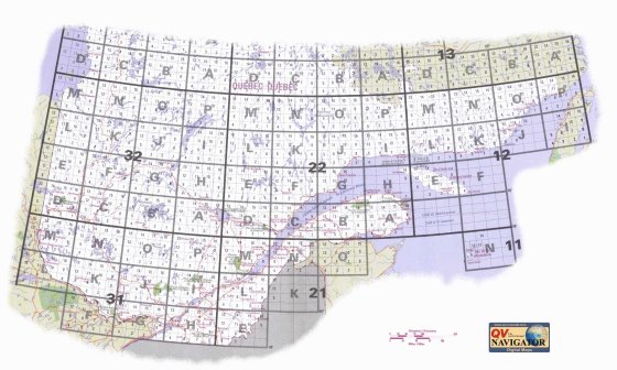
| Approximately 1000 seamlessly joined Toporama topographic maps at
1:50 000 covering Quebec as far north as the 53rd parallel. Toporama maps are
downloadable low-resolution topos produced by the Centre for Topographic
Information (a branch of Natural Resources Canada) collected here on CD-ROM.
Please note that Toporama maps are not as detailed as Federal NTS map sheets. For instance, contour lines are indicated but not numbered, and not all lakes and rivers are named. Here's a visual comparison between the digital Toporama maps and a Federal NTS map sheet: |
Toporama CD-ROM image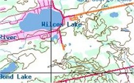 |
1:50 000 Federal NTS map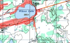 |
Includes the official "Canadian Geographical Name Database", with more than 350 000 entries of lakes, rivers, mountains, villages and towns, as well as the Touratech QV2 software required to view the maps. lso includes a 25 day trial period to sample the GPS-functions and Quo Vadis software. System Requirements:
|
 |
Price and availability subject to change. Shipping and applicable taxes extra. Questions about anything on this page? Please e-mail us. Last modified: April 15, 2005 |
| Topographic Maps on CD-ROM main page |
| What's New · Home · Search · Books on Canada · Canadian Maps and Charts · Ordering · E-mail Us |
©Federal Publications Inc., 1998 - 2016, 2000, 2001 425 University Avenue, Ste. 401, Toronto, Ontario, Canada M5G 1T6 Phone: (416) 860-1611 or toll-free 1-888-433-3782 · E-mail: info@fedpubs.com |