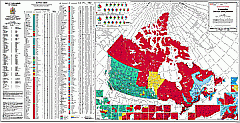
A matching table lists the members elected and gives detailed voting data.
Charts summarize the 1997 and 2000 election results by province and territory.
A separate table lists Senate membership as of March 2001.
The 37th Parliament of Canada (Map) |
| This map sheet shows the membership of the Parliament resulting
from the general election held in November 2000. A large map of Canada (with 27 urban insets) shows the election results, with Federal Electoral Districts coloured by the winning party. |
A matching table lists the members elected and gives detailed voting data. Charts summarize the 1997 and 2000 election results by province and territory. A separate table lists Senate membership as of March 2001. |
|
Size: 29.5 in x 57 in or 74.9 cm x 144.8 cm Scale: 1:7,500,000 Published by Natural Resources Canada, 2001. |
| Catalogue No. | MCR 0196 |
| Price | $10.75 |
| Format | Map |
| Pages | |
| Language | Bilingual |
| Price and availability subject to change.
Shipping and applicable taxes extra. Questions about this product? Please e-mail us. This page last modified: May 24, 2001 |
| Government and Politics main page ·Maps of Canada main page |
| What's New · Home · Search · Books on Canada · Canadian Maps and Charts · Ordering · E-mail Us |
©Federal Publications Inc., 1998 - 2016, 2000, 2001 165 University Avenue, Toronto, Ontario, Canada M5H 3B8 Phone: (416) 860-1611 or toll-free 1-888-433-3782 · E-mail: info@fedpubs.com |